I’ve been researching Nassau to determine what I’d like to see and do during our brief visit by cruise ship. Aside from Miami’s South Beach, Nassau presents the only opportunity to see and learn about Caribbean history on this trip. Below are my notes and lists from reading various texts (mostly Fodors) and web articles. I’m sure I’ve overdone it, listing far more than anyone could see within the estimated eight hours of time we’ll have for shore leave. So now you have choices to make and priorities to set, which might be influenced by that day’s weather.
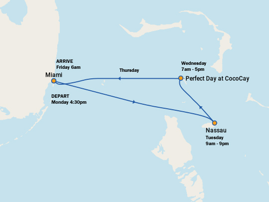
Our cruise itinerary is graphically depicted as follows…
I’ve read that of 700 islands in the Bahamas, only 30 are inhabited and that 70% of the population resides on New Providence island where the capital city of Nassau is located. Understandably this may have intensified considering the recent destruction of Grand Bahama island by hurricane Dorian.
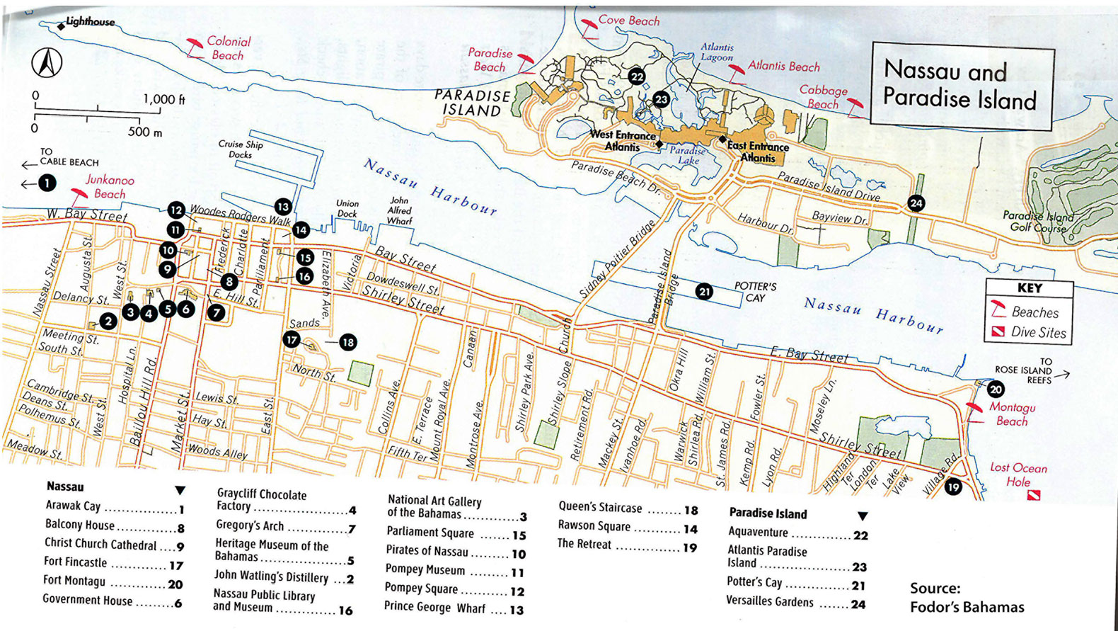
Downtown Tour
The cruise ship docks (up to 6 or 8 at a time!) dump passengers directly into the heart of old Nassau which is perfect for a walking tour. Those headed for Paradise Island will take a vehicle over one of a pair of bridges or a water taxi to access this lush but totally artificial “paradise.” I’m more interested in authentic culture, food and history so I intend to skip P.I.
Alternative interactive sightseeing map
Arts
Included in the walking tour map are several sites focused on the arts, and artwork was publicly displayed on walls and along streets throughout our walk. Resources include:
Beaches
While exploring the town will be priority #1, depending upon time and weather we may also want to visit a beach. Here is a brief description of them. (We never got to any of them. Spent time drinking rum at John Watlings instead.)
Junkaroo
This is the man-made urban beach closest to the cruise ship terminal. It will be surrounded by vendors and likely have the poorest water quality. No privacy.
Cable Beach
Next beach west from Junk Beach and named for the location where buried communications cables arrive at the island. It is now built up with resorts. The public access seems to be at Goodman’s Bay Park at the east end of the beach. It is served by bus #10 and taxi’s from the cruise port. Goodman’s gets largely positive reviews and is said to be popular with locals and tourists alike. If time is constrained, Goodman’s Bay Park is likely the best beach to access from the cruise terminal. There is a public small craft launch ramp here so expect jetskis.
Love Beach
And next continuing west along the north coast is Love Beach which is quieter than Cable / Goodman’s Bay but also sealed from public access by private land owners. Fodor’s suggests looking for a vacant lot to walk across to the beach. I’d recommend access at Nirvana Beach Bar (cash only). Love beach is in the flight path of the airport. You can get to both Cable Beach (Goodman’s Bay Park) and Love Beach by bus route #10 for $2 per person one-way. The ride to Love Beach takes about 40 minutes according to reviews. see some drone footage
Adelaide Beach
Driving much further around the airport to the village of Adelaide is where you’ll find Adelaide Beach. This is a very quiet local beach with no amenities. Access to the beach may require walking across vacant but privately owned land. Water is said to be clear but shallow.
Montagu Beach
Montagu is of course adjacent to historic Fort Montagu on the opposite side of the island at the eastern entrance to the harbor. It is unlikely that time would permit us to visit this site.
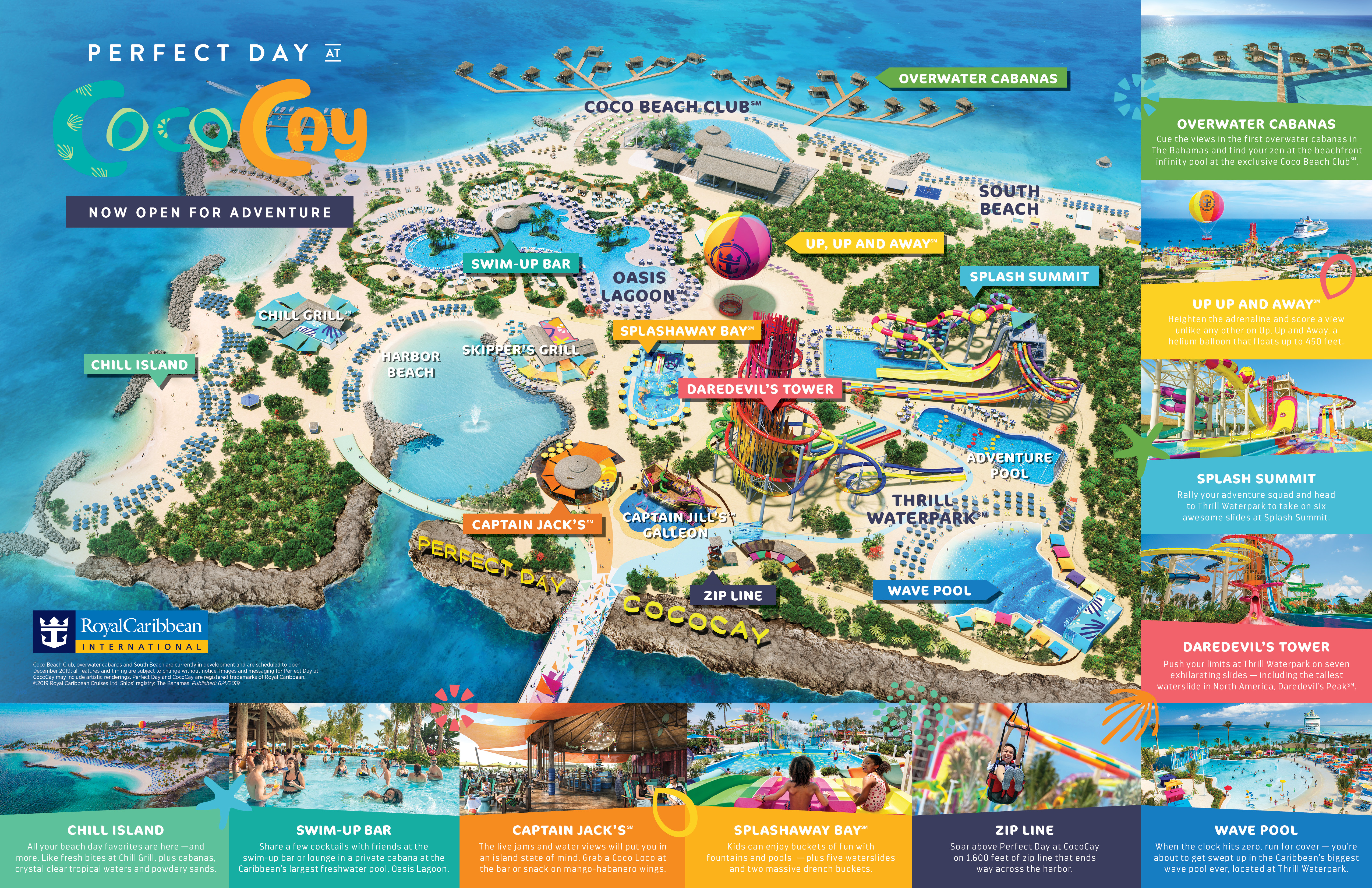
Coco Cay - cruise day #2
Coco Cay - formerly Little Stirrup Cay (or Key) - is a privately owned island by Royal Caribbean where they provide beach and waterpark fun for passengers in a secure and controled environment. There are many attractions, some requiring additional fees. Here is a diagram of the island. We’ll strategize our activities based on wind, weather, and spur-of-the-moment desires.
Video slideshow of our cruise…